Trail Walking La Robine-sur-Galabre - 20191209_Passerelle Bès_Lame Facibelle_Belvédère Pas d'oiseaux  - Photo

20191209_Passerelle Bès_Lame Facibelle_Belvédère Pas d'oiseaux

© OpenStreetMap contributors
Length
Length
13.6 km
Max alt
Max alt
1230 m
Uphill gradient
Uphill gradient
793 m
Km-Effort
Km-Effort  
24 km
Min alt
Min alt
774 m
Downhill gradient
Downhill gradient
812 m
Boucle
Boucle
No
Creation date :
2019-12-10 09:02:42.142
Updated on :
2019-12-13 14:30:18.367

(0 Reviews)

Walking
Walking
6h30
Difficulty : Difficult

Scan this QR Code to open this trail in the SityTrail application

FREE GPS app for hiking

Logo SityTrail SityTrail

IGN / Geographical institutes

Download SityTrail from the App Store Download SityTrail from Google Play

Logo SityTrail SityTrail World

The world is yours!

Download SityTrail from the App Store Download SityTrail from Google Play Download SityTrail on Huawei AppGallery

About

Trail Walking of 13.6 km to be discovered at Provence-Alpes-Côte d'Azur, Alpes-de-Haute-Provence, La Robine-sur-Galabre. This trail is proposed by PapouBertrand.

Description

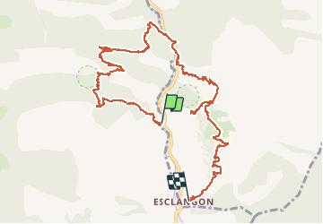
Randonnée du CSA-Gap, Marche de 6h30, 14 km et 800 mètres de dénivelé à découvrir à Esclangon, ALPES-DE-HAUTE-PROVENCE, PROVENCE-ALPES-COTE D'AZUR.
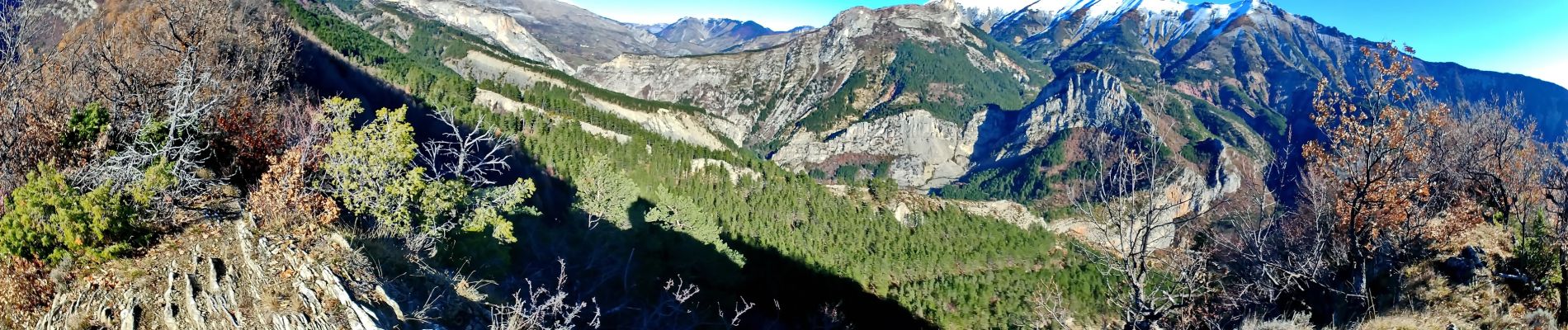
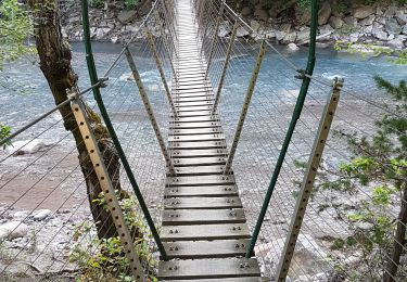
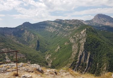
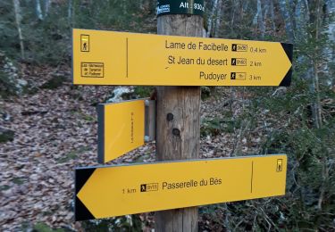
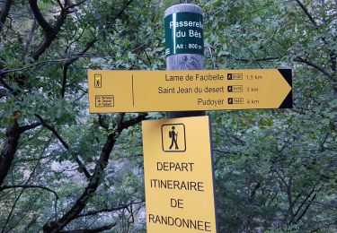
Départ de la passerelle du Bès, de magnifiques paysages sauvages et somptueux.
Il faut deux voitures ou revenir par la route à pied.

Elevation profile

Photos

Positioning

Country:
France
Region :
Provence-Alpes-Côte d'Azur
Department/Province :
Alpes-de-Haute-Provence
Municipality :
La Robine-sur-Galabre
Location:
Unknown
Start:(UTM)
282144 ; 4898469 (32T) N.

Trails nearby

Trail Walking La Robine-sur-Galabre - LAMBERT mourre du barri - Photo
Walking
RobinMicheline

Walking

Very easy
(1)
La Robine-sur-Galabre, Provence-Alpes-Côte d'Azur, Alpes-de-Haute-Provence, France
12.6 km | 21 km-effort
4h 18min
Yes
Trail Walking Barles - Grande Cloche de Barles - Photo
Walking
motardes04

Walking

Easy
(1)
Barles, Provence-Alpes-Côte d'Azur, Alpes-de-Haute-Provence, France
11.2 km | 20 km-effort
3h 58min
Yes
Trail Walking La Robine-sur-Galabre - LA ROBINE . Les Pharaons Au fil de l eau o m s - Photo
Walking
RobinMicheline

Walking

Easy
(1)
La Robine-sur-Galabre, Provence-Alpes-Côte d'Azur, Alpes-de-Haute-Provence, France
8.4 km | 14.3 km-effort
3h 7min
Yes
Trail Walking La Robine-sur-Galabre - AINAC Col S Antoine . Feissal o s  - Photo
Walking
RobinMicheline

Walking

Medium
La Robine-sur-Galabre, Provence-Alpes-Côte d'Azur, Alpes-de-Haute-Provence, France
12.7 km | 19.3 km-effort
3h 47min
Yes
Trail Walking La Javie - 04 Boucle de Facibelle par chapelle St Jean - Photo
Walking
zardoc13

Walking

Medium
La Javie, Provence-Alpes-Côte d'Azur, Alpes-de-Haute-Provence, France
7.7 km | 14.5 km-effort
2h 51min
Yes
Trail Walking La Javie - Le vieil Esclangon et panorama du vélodrome - Photo
Walking
zardoc13

Walking

Easy
La Javie, Provence-Alpes-Côte d'Azur, Alpes-de-Haute-Provence, France
5.3 km | 9.6 km-effort
1h 42min
No
Trail Walking Le Brusquet - LE MOUSTEIRET. Ruine Chalvet .Col de l Escuichiere . Le Villard o m s  - Photo
Walking
RobinMicheline

Walking

Medium
Le Brusquet, Provence-Alpes-Côte d'Azur, Alpes-de-Haute-Provence, France
10.1 km | 17.3 km-effort
3h 25min
Yes
Trail Walking La Javie - lame de facibelle - Photo
Walking
gibello

Walking

Easy
La Javie, Provence-Alpes-Côte d'Azur, Alpes-de-Haute-Provence, France
7.4 km | 14 km-effort
3h 56min
Yes
Trail Walking La Javie - Digne : Facibelle - Photo
Walking
phidge

Walking

Medium
La Javie, Provence-Alpes-Côte d'Azur, Alpes-de-Haute-Provence, France
7.5 km | 13.8 km-effort
5h 13min
Yes


Close
My subscriptions